The Eventider's News
Issue Four Spring/Summer 2005

Page 7
Avocet's Log,
Where is yours?
Opening Page Coronette The Constitution Paint Offer Coronette's Log
Scran Bag! Restoring Lyekka Westwater The Burgee Events News
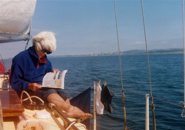
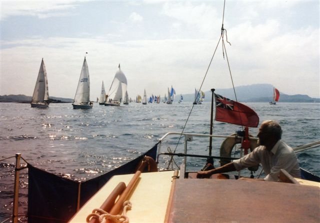
AVOCET Summer 2004 Cruise

2004 - Summer Cruise - Avocet - 20th July to 8th August.
Avocet spent the winter ashore at Skippool on the river Wyre in Lancashire, home of the Blackpool and Fleetwood Yacht Club. We visited her earlier in the summer to patch, paint and polish, but she was still ashore when we arrived for our summer sail, half-way through July. Spring tides were needed to lift her in, and after a couple of nights on dry land, the days spent rigging and provisioning, in she went and away we went, all on the same tide.
It was windy, with an inshore waters forecast in Liverpool Bay of SE 5-7, becoming SW 3-4 later. Once down the river to Fleetwood we picked up an all-tide mooring and reviewed the situation in a horizontal position. (It had been a busy morning...). Meanwhile the wind eased and veered, so we scooted north across Morecambe Bay, or maybe skated would be a better term, as at times we had just a metre under the keel. We got rained on, and becalmed - usual story - before motoring up the Walney Channel leading to Barrow in Furness, and picked up a mooring below the Castle on Piel Island, a scenic and peaceful spot, sheltered from all but SE winds.
Peaceful that is, until the wind did come SE and blustery in the early hours, with the fetch at high water coming right across Morecambe Bay.
The log states: 'Windy, wet, bouncy, roly, noisy', and that sums up our night!
13 miles, 4 hours 20 mins.
Wednesday 21st July
The forecast of S or SW 3-4, occasionally 5, sounded just right for a good downwind sail to Whitehaven in Cumbria, and so it was for the first couple of hours, but as the wind dropped, the south-westerly swell with southerly overtones caused slatting sails and a motion like riding a three-legged carthorse, so we were tortured into using the engine! The main feature of the trip (apart from the beautiful Lake District scenery) was a couple of cable-laying barges off Sellafield, which caused us some head scratching as to which side to pass. We chose the beach side, but a Dutch voice called up 'Yat Avocaat' on the VHF and directed us between the two vessels with precise instructions, i.e. " Turn 90 degrees to port NOW".
Towards the end of the trip we rounded St Bee's Head - she actually has two, north and south - and once sheltered from the swell had an enjoyable goose-winged run in warm sun for the last few miles to Whitehaven, entering with half an hour to spare, as the harbour entrance dries at low water. The inner harbour has a sea-lock and a good marina, with Tesco's next door!
38 miles, 10 hours 15 mins.
Thursday July 22nd
We locked out of the Marina at 0815, but we had left it too late on the tide and grounded in the outer harbour (muddy bottom). We were able to re-enter the lock, and repeated the exercise on the tide's return at 1130. Our intended destination was The Isle of Whithorn on the Machars Peninsular of Galloway, and the wind was on our side at last, with south-westerly 3-4 giving us a satisfying close reach across the Solway Firth.
We were making good progress, so at 1515 we changed our (mental) passage plan to destination Mull of Galloway. Half-way across Luce Bay the wind started to freshen from the south, and with quickly building seas we found ourselves racing wetly towards the Mull in a good F6. Although slack water was approaching, rounding the Mull wasn't much of an option in those onshore conditions - not for me at any rate! - so we slipped into the sheltered water behind the hook-shaped southern end of the headland and dropped the anchor in Tarbert Bay, with some relief on my part. (20.05 hours). Shortly after we were joined by another yacht, Jehu, also seeking shelter.
When the tide turned we could see the white water of the tide-race roaring eastward past the end of the Mull.
46 miles, 11hours 50mins.
Friday 23rd July
The next day the wind was still strong but had veered south-westerly. (Forecast: SW4 or 5, occasionally 6). High water slack was at 1530, which would give us the ebb up the west side of the peninsular. We decided against attempting the Mull in such boisterous onshore conditions and (uncharacteristically!) slept all morning, which showed that we must have been pretty tired. Around 1700 the wind suddenly dropped and we pumped up the dinghy and went ashore for a stroll.
We walked or scrambled right round the cliff-tops of the Mull, and could see no particular danger below apart from a patch of over-falls at the east end. In the main the over-falls extended well out to sea, but close inshore appeared relatively calm. We decided to go for the low water slack, but leave early to catch a bit of ebb up the west side, hoping to be in Portpatrick, on the Rhins of Galloway, before the pub closed. Some hope!
We set off at 2020, and entered the race at the east end of the Mull, which bounced us and splashed us but not much more. After that it was just a matter of whirlpools and swirlies, (That might be a home-made word!) and enjoying the spectacular cliffs. All went well until the tide turned against us off Crammag Head, and the light started to fade. We tried to find a reverse eddy close inshore which exists at some states of the tide, but nothing was very apparent, and anyway it got too dark to be in close.
After a motoring marathon (big yawn) we finally entered Portpatrick Harbour at 0200, having been tantalised by the lights of the town for ages. It was low water and the leading lights were the vital ingredient in navigating the narrow, rocky entrance. Because we were so low, the forward light appeared almost as high as the rear light, which made things more difficult, but we've been there a few times now and were soon safely tied up to the massive harbour wall. I would like to say all was peaceful, but an Irish gin-palace was over from Bangor and still in party mode, providing a minor irritation (yes, understatement). Nothing, however, could have kept us awake for long.
17 miles, 5 hours 45 mins
Saturday 24th July
It was wet and windy in the night, and still blowing well onshore in the morning. The sea was covered in white horses and force 6 was mentioned on the forecast; all in all a good day to spend ashore! When the sun appeared it was warm and sheltered in the harbour.We had showers at the superloo (£1.20) and sat and watched the antics of the resident black guillemots, delightful birds with red feet which nest in holes in the harbour wall. Another power-boat arrived, from Donaghadee, Northern Ireland, a classic Fairey Huntsman with a family aboard. They rafted up to us, all shaken up and exhausted by a rough crossing of the North Channel - and it had only taken them an hour to cover the 22 miles!
We shopped at the tiny village store, then walked a couple of miles north along the cliff path to the Killantringan Lighthouse, which had guided us the previous night.
The Downshire Arms provided us with a delicious meal that evening, and enjoyable live music rounded off our day.
Sunday 25th July
The next day was sunny and breezy, this time with force seven creeping into the forecast, although the sea was going down and one or two yachts ventured out. We passed the day doing some boat maintenance and enjoying the sun, and chatting with our Irish neighbours. We had another cliff walk, south this time; the wild flowers were lovely and for a while we lay in the sun in a sheltered spot. (I mentioned that for a reason!) The wind died away in the evening, the gin-palace departed, and the harbour was all peace, with the strains of a (well-played) harmonica drifting out from one of the boats. We got out the next chart we would need - The Clyde Estuary.
Monday 26th July, Portpatrick.
After all that rest we were awake for the early shipping forecast, and at 0615 motored out of the harbour into a quiet, damp, grey morning, with a bit of residual swell but very little residual wind, and that from the north-west! We did have the tide with us however, and for the next couple of hours we followed the coast north and enjoyed the rocky scenery and the abundant wildlife, which included large rafts of eider ducks and the spectacular diving gannets. Once past Corsewall Point, round which the Stranraer to Larne Sea- Cats can suddenly - and heart-stoppingly - appear, we shaped a course for Sanda Island, south-west of the Mull of Kintyre, hoping to anchor there for lunch over slack water. This tiny island now has a pub, but no other human inhabitants apart from the publican’s family – a tempting proposition.
Millpond conditions now prevailed, not good for sailing but excellent for nature study! We saw schools of porpoises, manx shearwaters skimming low across the sea, some enormous seals, puffins, guillemots and their young continuously calling to each other, and the pirates of the sea-bird world, the great skuas.
As we approached Sanda from the south, a westerly breeze sprung up, so we forsook the pub in favour of a sail, and had a cockpit picnic instead. We had a good look at the notorious and awe-inspiring Mull of Kintyre as we would be returning by that route, then goose-winged east through Sanda Sound, navigating carefully because of submerged and awash rocks.
By 13.30 we had the genoa up and were able to broad-reach goose-winged on the starboard tack up into Kilbrannan Sound, with the dramatic scenery of Island of Arran to starboard, and the Kintyre Peninsular to port. We were heading for Campbelltown, the first safe haven up this part of the coast. As we approached the entrance to Campbelltown Loch, the wind veered back into the northwest and freshened, so that we had a lively tack up the loch, first rounding the impressive island of Davarr which guards the loch entrance. At 18.50 we dropped anchor off the Campbelltown Sailing Club, and soon after rowed ashore in search of adventure and….food.
Later, after the worst takeaway baked spud I have ever had (sorry Campbelltown!), as Brian undressed for bed – apologies for intimate details – I noticed that he was covered in bites, presumably from our walk at Portpatrick. After anointing him tenderly with bite-ointment I also undressed and found that I too was covered in nasty, scabby bites. That night they started to itch…. 40 miles, 12 hours.
Tuesday 27th July
We started the day with an ‘incident’… We decided to sail off the anchorage, which involves me standing by the sheets and tiller ready to make way, while Brian hauls up the anchor. Normally he yells as he feels the anchor come off the bottom, and I sail away. On this occasion, anchored in deep water, Brian didn’t feel the anchor leave the sea-bed, and I wasn’t paying sufficient attention to my surroundings to notice the boat blowing gently onto a lee shore. I did notice when we were still some 50 metres off, but simultaneously our keels connected with a groin constructed of granite rocks. (Imagine nasty graunching noise here!) We went into our well-worn ‘motor on, rock boat’ routine and made an undignified getaway, not un-noticed by bystanders ashore. (11.10) The wind was fresh and westerly, and early fog was lifting.
We had read in our cruising guide that there was a cave painting on Davarr Island that was well worth a visit, so sailed round to the south side of the island, and anchored in the lee of the causeway that connects it to the mainland at low tide. Some walkers ashore anxiously waved and shouted at us – we assumed they thought we were going to try and sail over the Causeway. Maybe others have!
We went ashore in the rubber dinghy and explored caves until we found the painting – a copy of a Dutch Master’s crucifixion, painted by a local art teacher over a hundred years ago. He had been inspired by a dream to paint the mural and it has become a place of pilgrimage.
Having had our bit of culture and spirituality, we again sailed off our anchorage, but this time had the engine running ‘in case’, having been a little unnerved by the earlier incident! (13.55)
In a good force 4 and sunshine we reached briskly up Kilbrannan Sound; it didn’t last. An hour later the breeze died and the sun was hot. We sun-bathed lazily until the tide turned and the scenery started overtaking us, and thereafter motored or sailed as the wind came and went. We had hoped to make Ardrishaig, at the southern end of the Crinan Canal, but the gentle conditions and the lovely surroundings lured us into Carradale Bay, on the West side of the Sound. Luck was with us this time; the forecast South-easterly stayed away till the next day and we had a peaceful, but itchy, night with a stunning sunset and complete solitude. Oh yeah, and Brian cooked a delicious supper!
12 miles, 6hrs 45mins.
Wednesday 28th July
Having got irretrievably into leisurely starts, it was 0940 before we sailed quietly out of the anchorage and headed north again up Kilbrannan Sound. On cue, the easterly breeze died and we motored all morning through the quiet grey day, past Arran’s brooding mountains, slowing as we approached the north end of the island to give way to a ‘Calmac’ (Caledonian MacBrayne) ferry entering Loch Ranza. We now entered Inchmarnock Water, a huge marine crossroads. Straight on was the island of Bute and access to the stunning Kyles; to starboard the Firth of Clyde stretched away south-eastward; to port was Lower Loch Fyne, our route north-west to the Crinan Canal.
At 1340 enough of a south easterly had materialised to enable us to run goose-winged, making gentle progress to within five miles of our destination. With a bit of motoring we soon entered Loch Gilp, and at 1940 tied up to the Ardrishaig sea-lock waiting pontoon.

We were luckily in time to get a key for the facilities; we strolled round the village, visited the ubiquitous Co-op, inspected the first flight of locks, then indulged ourselves in the shower-block!
30 miles, 10 hours.
Thursday 29th July
The first opening of the sea-lock was at 0830 and we managed to be ready on time. Once in the basin we became quickly acquainted with our fellow travellers. Working through a canal is all to do with co-operation and teamwork, and we had good teachers in the family crew of another classic motor cruiser, a Fairey Swordsman, Spirit of Cumbrae. They were regular users of the canal and knew exactly what to do. By the end of the day we were through the nine miles and fifteen locks of the canal, bar the final sea-lock. We had risen to 68 feet above sea level and had a scenic treat. We had even taken time for a wet walk up the hill at Cairnbaan to see some 5000 year old ‘cup and ring’ rock carvings – we were suitably impressed. On our way back to the boat Brian got chatting to what he thought was a local builder, but he turned out to come from the next village to Brian’s birthplace in Derbyshire!
We arrived at Crinan too late to lock out, and anyway the lock was full of trawlers waiting to unload in the morning. The basin was crowded but we found a berth alongside a home-made 22foot sailing cruiser (A Hornblower) with a peat-burning stove making copious smoke. Also in the basin was the famous steam puffer ‘Vital Spark’, star of the Para Handy tales.
We had just settled down for the night when a very noisy firework display erupted at close quarters, setting off a couple of terriers on the next boat and keeping the midges awake! (As it happened, we never got bitten again like we had at Portpatrick).
Pretty as Crinan was, we felt a bit claustrophobic and were keen to get back to the open sea. The Western Isles beckoned.
9 miles.
Friday 30th July
By 0850 the sea-lock at Crinan was clear of fishing boats and the yachts crowded in expectantly, keen to be released into the beckoning sea. At O920 the gates opened and out we poured into Loch Crinan, the larger, speedier yachts disappearing in a matter of minutes. It was a quiet, hazy day with light and variable winds as forecast. The scenery, though was stunning, especially the view up Loch Craignish. Our intention was to sail to the Island of Luing, home of fellow Eventide owner, Norman Garnett.
We headed north-east toward Dorus Mor, a notorious passage between the mainland and a group of islands, where the tide runs fast and the bottom depth varies from 62 to 19 metres. Consequently it can be very turbulent, given the right, or should I say wrong, conditions. Today it was in placid mood as the tide carried us speedily through, but even so there were large whirlpools to be seen and the boat swung about as she encountered them. As we sailed out into the Sound of Jura, Norman rang, and needed reassuring when we told him where we were, as Dorus Mor’s reputation is second only to that of the Gulf of Corryvreckan!
Now heading north, we were able to sail to the light westerly breeze, and headed for Shuna Sound. This took us up the East side of Luing, with the island of Shuna to starboard. Luing is one of a group of islands heavily mined for their slate in days gone by. The southern half of the island however is very green and fertile and home to a number of indigenous cows, which deal well with the rugged terrain.
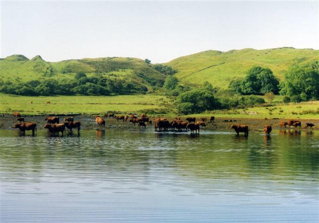
On our last visit we anchored on the west side of the Island in a rocky pool near Norman’s home. This time we chose Ardinamir Bay on the north-east corner of the island, sheltered from the north by the adjacent island of Torsa. The entrance was only a few metres wide, between two submerged rocky outcrops, and we motored in very gingerly, peering over the side to pick our route. ( 12.25) It was an idyllic spot, surrounded by woods and rugged green hills, with cows standing in the shallows along the beaches of the bay. The water was so clear we could see the anchor, and watch starfish and crabs wandering around on the seabed. And the sun was shining!
We had planned to walk the mile or so across the island to Norman’s place, but while we were still pottering around the boat, he arrived in his pick-up. We paddled the rubber dinghy ashore through underwater forests of kelp, and later enjoyed showers and a real feast, courtesy of Norman and his friend and neighbour, Pam. 11 miles, 3hrs 45mins.
Saturday, 31st July
This was as near perfect a day as one could hope for – calm, warm and sunny first thing, so that we just hung about the boat, watching the wading cows, listening, and soaking up sun and atmosphere. There was a heronry in the trees along the shore, and the odd buzzard wheeled overhead. Eventually we got ourselves ashore and walked across this beautiful island to Fladda, the small former slate-mining settlement where Norman lived, almost opposite the tiny island shop. We did some shopping, then returned to the boat for a sail with Pam and Norman.
At 1405 we sailed off the anchorage in a light westerly, and slipped quietly through the narrow exit, submerged rocks clearly visible within feet on either side. We sailed downwind across Shuna Sound, then south-east, picking our way between islets, and heading towards the large marina at Croab Haven. Here, dozens of yachts were gathering for a Sail Scotland Week race the next day; Norman and Pam waved to a couple of boats that they knew, Border Raider and Magic Mood, another Maurice Griffiths designed boat.
As the afternoon wore on, we headed back upwind, tacking through the islands again to return to Ardinamir Bay, just needing the engine to renegotiate the entrance channel before dropping the anchor again through the clear water onto a patch of sand. (17.25)
We had a date that night; one of the islanders, John, was having a sixtieth birthday ceilidh in the Community Hall at Toberonochy, and all the seventy-odd islanders were invited, including us.
At a island ceilidh everyone brings food and drink, and members of the community take it in turns to entertain. We heard John’s small grand-daughter reciting gaelic poetry, and, among other things danced ‘Strip the Willow’! We returned to the boat at 01.15, with a full moon to light our way across the still water of the bay.
Sunday 1st August.
At 1010 we dragged ourselves away from this little paradise, motored out into Shuna Sound, and headed south-east for half an hour, leaving the island of Shuna to starboard. Our plan was to visit Oban, then the Island of Mull. The breeze was itself south-easterly, so we had to round the south-east corner of Shuna before we were able to sail south-west to pass to the south of Luing, before heading north for Oban. The Sail Scotland racing was just getting under way, and large numbers of assorted yachts started to bear down on us from the direction of Croab Haven. First came the classic yachts, then the family cruisers, then the ‘big boys’.
For a short while we were able to pretend we were leading the fleet, especially as we were able to round the southern tip of Luing (1220) and head north, while they had to round a buoy further out. As we broad-reached north up the Sound of Luing, in a freshening breeze, we were surrounded by colourful spinnakers and sleek crews, everyone enjoying the sunshine but in a competitive sort of way! They chatted to us as they passed, and it became clear that firstly there were at least 170 yachts in the race, and secondly they were going to Oban for the night. They were obviously all going to get there before us… We exchanged glances and changed our (mental) passage plan, deciding to forget Oban in favour of Tobermory. The race fleet was going there too, but wouldn’t arrive until Wednesday.
We headed across the Firth of Lorne to the south-east coast of Mull, arriving off the entrance to Loch Spelve at 1600, the wind now light and south-westerly.
At 1715 we rounded Duart Point with its picture-postcard castle, on the easternmost coast of Mull, then turned north-west up the Sound of Mull, with the Isle to port and the Morvern peninsular to starboard. Each Scottish Island has its own character, and Mull is no exception. It is mountainous, but the valleys are close to sea-level, so it’s dramatic profile is clear against the sky.
At 1900, with Loch Aline to starboard, we motored to counteract an adverse tide and light conditions – we still had twelve miles to go. Within the hour however, the wind had piped up from the south-east and the ebb had started, so we were able to roar along goose-winged. Looking back down the Sound, Mull’s mountains were topped with dramatic clouds, turned pink by the setting sun. Ahead, the first lights of Tobermory were beginning to show. We were full of anticipation as we had wanted to get to Tobermory last year and hadn’t made it, and it had been our main goal for this year.
Calve Island lies across the entrance to Tobermory’s bay, making it sheltered and lagoon-like. Had we arrived on the first of the ebb we could have entered south of the island, but it’s a ‘local knowledge’ type of entrance, so we carried on past Calve Island, belting along in a rising wind, and at 2100 we rounded its northern end on a storming beam reach. Brian’s brother Graham phoned just then, so he got a running commentary on our precipitous arrival! Having motorised and doused the wild sails we cruised around the sea-front but couldn’t spot any free visitor’s moorings, so picked one up on the west side of the harbour under a steep wooded slope, away from the public eye, but with a fine view of the colourful waterfront. (2140)
With a strong feeling of satisfaction we sat in the cockpit, boat stew bubbling on the stove, and watched night fall on Tobermory. 38 miles, 11.5 hours
Monday 2nd August
The forecast the next day, SE5-6, with a Strong Wind Warning in place, gave us the excuse we needed to stay in port for the day. We dinghied ashore and window-shopped our way along the picturesque sea-front, where the merchandise (and prices) appeared geared to wealthy American tourists. We visited the much more parochial local museum and indulged in coffee in the Chocolate Shop, before coming down to earth in the co-op. When we returned to the boat with the shopping, Spirit of Cumbrae was moored nearby, and her skipper rowed across for a chat. Later we returned ashore and climbed into the hinterland. It was sunny and warm in spite of the breeze and the views were breathtaking, although we couldn’t see the Atlantic from there. Our return to the quayside coincided with the arrival of a mobile chip-shop. Bliss!
With Brian’s daughter getting married on the 13th August, it was now high time to head south. With a decent forecast we could sail back down the west coast of Mull….
Elizabeth Letzer and Brian Platts. Eventide 24, Avocet.
All the photos on way we hear! Look forward to the next episode and hearing of 2005's exploits!
2004 - Summer Cruise – Avocet – 20th July to 8th August. Part Four
Tuesday 3rd August, Tobermory.
Doing our homework for an anti-clockwork circumnavigation of Mull, we found ourselves short of the necessary chart (must have left that one at home…) The Tobermory bookshop sold charts, but in our experience the local chart is often sold out, especially in August. At 08.30 that morning we motored across to a waiting pontoon to fill up with water, and meanwhile kept our binocs trained on the bookshop. The moment the lights went on Brian beetled off, and luckily for us the required chart was in stock. The urgency was to do with catching the last of the north running tide up the Sound of Mull, and also the pressure of time, with ten days to go before Brian’s daughter got married in Peterborough, not to mention myself due back at work in a week’s time. (True to form, neither of us yet had anything to wear to the wedding!)
The forecast for this day, hopefully the climax of our cruise, was for SW v NW 3 or 4, increasing 5 later, rain followed by thundery showers, visibility moderate to poor, improving, sea state slight to moderate. Not brilliant, but not terrible either….
Brian had made contact with the crew of a 24ft J24 class boat, Sandpiper from Portrush, Northern Ireland, who were taking the same route on their way home, and we had agreed to travel in company and keep an eye on each other. Accordingly, at 0925, we motored off the pontoon and bade farewell to Tobermory, and within ten minutes both boats were goose-winging their way up the Sound of Mull with a south-easterly force 3 pushing us along. It was a grey, threatening, moody sort of a day, and as we rounded Ardmore Point, the northerly tip of Mull, the visibility sea-ward was indeed poor. There was no sight of the island of Tiree, ten miles to westward, and also no chance of spotting Arnamurchan Point to the north, famed by its daily mention on the inshore waters forecast. (It is said that when a cruising boat sails north of this point she can return with a sprig of heather on her bowsprit, so this can be next year’s target!)
At this point also we lost our south-easterly, to be replaced by a light westerly, so on went the engine, closely followed by Sandpiper’s outboard motor (1050). In a slight sea, we set a course WSW for Caliach Point, seven miles distant and not in sight, after which we would be able to head south. Five minutes later, looking astern, we spotted a large sea-creature heading back down the Sound of Mull on the tide, now running south. It was probably a whale, but too far away to identify. Meanwhile we were having frequent sightings of porpoise, all heading after the whale. Must have been something good down there!
At 1140 we rounded Quinish Point, and five minutes later passed to seaward of Sgeir Mhor, which translates as Big Rock, which it was, half a mile off the coast. At this stage it wasn’t too foggy… Half an hour later, however, as we rounded Caliach Point in noticeable overfalls, the fog descended, and the log reads, "Oh Dear." Here we were, our big day navigating the fabulous west coast of Mull, and for all we could see we may as well have been off the coast of Lincolnshire.
But we weren’t! We were crossing Calgary Bay before rounding the next prominent headland, Treshnish Point, at 1250 hours. At this point, to our relief, the cloudbase lifted enough for us to at least see the coastline, although there was no sign of Sandpiper. Two miles off the starboard bow the Treshnish Islands loomed out of the fog, but Coll and Tiree remained invisible to the west of us.
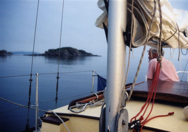
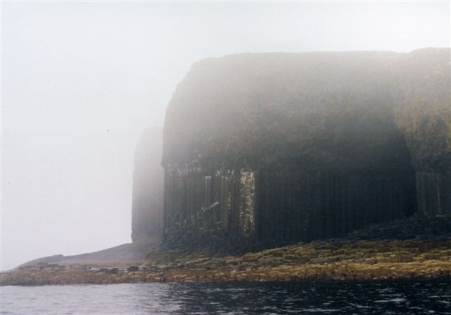
Brian has long wanted to visit Staffa, the island famous for Fingal’s Cave, so, with help from the GPS, we set a southerly course, and within the hour, Staffa too emerged from the murk. It started to rain as we approached, but in some ways the weather added to the atmosphere of this brooding rock with its striking geology, similar to that of the Giant’s Causeway. The massive cave entrance faces south, and as we edged round I nearly put the boat aground on a ledge of rock, so busy was I gawping… luckily Brian took a cautionary look at the echo-sounder and spotted the danger. As we puttered about, getting a good look with the binoculars and optimistically taking some photos, a tripper boat emerged out of the murk, and knowing exactly where to get close and avoid the rocky ledge, soon disgorged a load of tourists onto the island before disappearing again. The spell broken, it was time for us to go; we set a course for Iona, and motored on (1425).
At 1505, having seen nothing but sea and fog for over half an hour, Tiree at last became visible, some 15 miles to starboard. Visibility was improving by the minute. Five minutes later we could see Iona, and were reassured to find we were on course for the Iona channel. Behind us, we were glad to see Sandpiper emerge from the damp greyness, like us still motoring.
At 1540 we entered the Sound of Iona – the Ross of Mull to port, rugged and windswept, and Iona to starboard, desolate and damp, with clouds still obscuring the high ground. Because of time restraints we weren’t planning on visiting Iona on this occasion, but if we were I think the six coaches waiting in the ferry car park on Mull might have put us off! Perhaps better to feel it’s mystique from the sea and not try and do battle with hoards of tourists.
Anchored in the Sound was the Hebridean Princess, a modest but sturdy cruise liner with which my two surviving aunts have an affectionate relationship, having cruised the Hebrides on her for the last couple of years. The first year the weather was so bad that they saw nothing, so they tried again the following year and all was well! There are two anchorages on the Mull side of the Sound, one at the northern end, Bull Hole, and the other, Tinker’s Hole, to the south. We couldn’t see in, but could see two or three mastheads showing behind the rocks. It looked intriguing – another time perhaps.
An hour after entering the Sound we were through, and now accurate navigation was called for to pass through the infamous Torran Rocks, dozens of them, some visible, some submerged. We also got a whisper of a breeze from the west and thankfully turned off the engine and sailed for a change.
Sandpiper overtook, taking a south-easterly course rather than the southerly passage recommended by our pilot guide. Assuming they knew what they were doing, we followed them (you might think we would know by now, wouldn’t you, never to assume…) We later found out they were just guessing, but we both came safely through the Torrans, and set a south-easterly course to pass to the north of the island of Colonsay, which in view of the time looked a likely place to spend the night. With another fifteen miles to go, we soon had to motor-sail to get there at all.
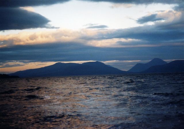
By 1900 were two miles off the northern end of Colonsay and were picking up quite a swell from the south-west, albeit a comfortable one. The light was wonderful as low sun broke through the clouds and bathed the mountains of Mull , Scarba and Jura. At 1950 we rounded Meall a Chuilbh, the northern tip of Colonsay, and turned south down the east coast of the island, heading for the only port, Scalasaig.
It was getting dark as we finally arrived off the tiny harbour, furled the sails and made fast to the pier. There were a couple of dedicated yacht berths but they were already fully occupied by very large yachts, so we made do with lots of fenders against pilings. Sandpiper lay outside two other yachts.
In the last of the light we went for a stroll ashore, following the only road up to the only hotel. We met the Irish, and compared notes on the trip. They were running low on fuel, so the good breeze forecast for the next day would hopefully save their bacon. Sheep slept in the ferry terminal car park and around the building. Somewhere nearby, some young things could be heard enjoying themselves, one of them rumoured to be Prince Harry! The island is known for its own unique flora and fauna, but there was no time now to explore – it was heads down, and away at crack of dawn with the tide. Unfortunately a swell came creeping round the island in the night and we had quite a bumpy time of it against the pilings. We should have anchored off and we knew it, but we were too tired…. 51 miles, 11.5 hours.
To be concluded.......................
2004 - Summer Cruise – Avocet – 20th July to 8th August. Conclusion
Wednesday 4th August
We woke to a bright and breezy morning, and The Caledonian Inshore Waters forecast offered NW 4-5 v N or NE 3 or 4. It looked like a sailing day! The south-going stream started around 0730 and by 0800 we had disentangled ourselves from the inhospitable pilings and followed Sandpiper out onto the water. Soon both boats were goose-winging their way merrily south, heading for the sound of Islay, 9 miles distant. Needless to say Sandpiper, with her racing lineage, was soon a dot in the distance, and we didn’t see her again, as she was bound for her Northern Island home.
Sadly the breeze didn’t last; at 0930 we let out the single reef, and as we became exposed to the Atlantic, the increasing south-westerly swell lead to cross seas and slatting sails. Time to switch on! By 1010 we had gained respite from the rolling seas as we entered the Sound of Islay, with Jura to port and Islay to starboard. We did this bit of the trip last year, but as it was foggy at the time we didn’t actually see it! The tide whisked us down the Sound, passing two of Islay’s seven distilleries, with strategically placed visitors moorings, which unfortunately we didn’t have time to use.
At 1130 we passed McArthur’s Head and its spectacular lighthouse to starboard, and we were through into the Sound of Jura, with enough north-westerly breeze to sail again. Our (mental) passage plan was to cross the Sound to the island of Gigha, then tackle the Mull of Kintyre the following day. However, the weather was so quiet we soon found ourselves motoring again, and we decided to save a day and go for the Mull, as the tides would work out well for us (1330). It was 27 miles to the Mull itself, and another 9 to the Island of Sanda, where we now planned to stop, so we settled down to a motoring marathon. There isn’t much written up in the log apart from fixes, which probably means there was a bit of snoozing going on, but we did spot a Minke whale at 1535!
Two hours later with 10 miles still to go, we did some calculations and slowed down a little, in order to arrive at the Mull approaching slack water. As we closed the Kintyre Peninsular we were able to get a good look with our binoculars, and spotted herds of nimble-footed goats perched on crags. The cliffs were high and forbidding, with clouds obscuring the tops. Although more massive and awe-inspiring than the Mull of Galloway, it lacked the latter’s spectacular geology.
At 2020 we passed the bleak and weather-beaten Mull light, and experienced some overfalls as we were half-an-hour early, but nothing major. Half-an hour later, we were in smooth water again, with Sanda in sight . There was no tide-race at the second notorious headland, Sron Uamha, it being slack water. I started to relax. (No, I never mentioned that I wasn’t relaxed, did I, but this was my first time round the Mighty Mull…) Enough of a westerly breeze now sprung up to propel us goose-winged towards Sanda, as the sun disappeared behind the Mull; it didn’t last, and we wearily motored the last four miles.
A little careful navigation was needed to gain Sanda’s anchorage, to the north of the island and sheltered by outlying rocks, and it was with some relief that we were at last able to drop the anchor in this remarkable spot. There were just two houses on the island, tucked beneath rocky heights – one was the pub and the other the landlord’s farmhouse, as he was also the farmer, and everything else! We were hungry and hoping to be fed, and the pub lights drew our rubber dinghy to the old stone jetty, where we were welcomed by a sheep-dog eager to round us up. Of course we were too late to get fed – we nearly always are! – but we supped some ale and yarned in company with a few other intrepid yachtsmen. After a long day at sea, and after beer on an empty stomach, our trip back to the boat was a bit hysterical, as the tide was whipping through the anchorage and I was sure we would be swept right past the boat. But we weren’t of course, with super-oarsman Brian in charge (well, sort of). We ate, and we slept! 57 miles, 13hrs 40mins.
Thursday 5th August
Once again a swell crept into the anchorage during the night, so by the time the tide started running our way, we were more than ready for the off. (0940) We motored out through overfalls to the north of the island, then, after carefully navigating round Paterson’s rock (which one can easily get swept onto by the tide) we headed south-east, and were able to sail to an east-north-easterly 3-4. Our intended destination was again Portpatrick, on the Galloway coast. Visibility was sufficiently poor that only Sanda Island, with it’s distinctive craggy lighthouse, was in view astern, and the forecast was for E v SE 3-4 occ 5, possibly 6, with slight to moderate seas. The writing in the log shows it was fairly lumpy!
For a couple of hours we continued to close-reach on a course of 150 degrees, with the wind gradually easing. At 1210 we heard a familiar high-powered thumping and soon a Seacat appeared from the haze and passed ahead, en route from Stranraer to Ireland. Ten minutes later the wind dropped, then veered south-easterly, and began to pick up; we could no longer maintain our track but sailed close-hauled on 210 degrees, with a view to tacking later. Visibility was still poor with no land in sight, and we were relying on the GPS to fix our position.
By 1400 we were roaring along in at least force 5 – 6 winds and moderate wind-over-tide seas, and at 1445, 7 miles west of Corsewall Point, we tacked inshore. The tide was now slack and would soon turn against us. An hour later we started the engine to cross the track of an approaching high-speed ferry. Because of its speed and the poor visibility it was only actually in sight for three minutes…
At 1605 we at last sighted land a couple of miles ahead. The sea-state was easier now that the wind was with the tide, and we were coming into the lee of the land. We sailed to within 200 yards of Graig Laggan Beacon, on the northern Rhins of Galloway, then stowed the sails and motored down the coast in quiet waters, again spotting goats gambolling on the rocks. At 1830 we passed Killantringan Light, and half an hour later entered Portpatrick harbour. The superloos were closed, but the pubs were open, and there was a ceilidh in the village hall. We chatted with the skipper of a catamaran that had come down from the Clyde approaches, arriving just before us, who said he had clocked 30 knots of wind at times – force 7. No wonder we had a good sail!
Friday, 6th August
We have navigated the Mull of Galloway several times now, so know the drill, at least according to Willie Ramsey’s Law. Willie is the harbour Master at Portpatrick, a retired fisherman who travels by bike and always seems to be there when you need him. We needed him first thing to provide some diesel from his shed, and to give advice on the conditions – thick fog! Willie’s way of rounding the Mull is to leave two hours before slack water and hug the (very rocky) shore, where there is a reverse eddy to carry one down to the Mull against the tide, then catch the flood eastwards, As hugging the shore means about 20 feet off, fog isn’t too much of a problem – in theory! Also, Willie predicted that the fog would lift in an hour or so.
If time had not been a problem the fog would have kept us in harbour, but the forecast was reasonable – W or SW becoming variable 3-4, so we bit the bullet and took the plunge, to use a couple of colourful metaphors! At 0805 we ventured out of the harbour into a confused, lumpy sort of sea – and thick fog.
We headed south and tried to hug the cliffs as we have done before, but the sea state and lack of visibility made it impossible to make our usual progress. By 0930 we were off Logan Point, and it was clear we were not going to make the Mull before the tide turned against us in another hour or so, and that would stop us in our tracks! We decided to head out to sea and take the Mull wide, outside the extensive over falls that would occur as the tide speeded up. We headed south, still in thick fog, then, at 1030, south-west, to meet head-on large seas that were building up as the south-westerly swells approached the peninsular. By 1100 the seas had eased enough to enable us to head south again, the tide now with us. An hour later were two miles south of the Mull and able to head east, motor sailing close-hauled in a south easterly breeze. Although it was clearer we still hadn’t seen the Mull! Almost immediately we hit over falls, as we were whooshed along at over 10 knots in the tide-race, and were back in thick fog. At least we wouldn’t meet a sea-cat out here…. By 1245 we were seven miles east of the Mull and still surrounded by the whirlpools of the tide-race. The sun was trying to break through but there was still nothing in sight – more lovely scenery missed!
At 1330 we spotted the Isle of Man, and shortly afterwards were at last able to see the Mull along way astern.
At, 1500, on the VHF, we heard the coastguard dealing with a boat in trouble back on the west side of the Mull. He had lost power and was at the mercy of the tide. We sympathised with him! It was now warm and sunny, though still hazy, with flat seas. I came up from snoozing below to find the auto helm in charge, and Brian sun-bathing on the foredeck! What a difference a few hours can make. We were approximately 21 miles from our destination of Whitehaven. Although the Isle of Man looked very tempting, it was directly upwind, and at least we could get home from Whitehaven by train if necessary! The Coastguard was warning of a southerly gale in a couple of days so things were getting tight.
For the next few hours we steamed steadily towards Whitehaven through calm blue seas and sunshine, so that the distinctly dodgy conditions we had encountered earlier seemed like last night’s dream. Quiet seas make for good nature watching; we saw a lot of enormous, white mushroom-like jellyfish off the Cumbrian coast. I’m sure they must be something to do with Sellafield.
With low water around 1600 there was no problem about entering Whitehaven Harbour when we arrived at 1925, and entered the sea-lock.
At 2000 we tied up in Whitehaven’s marina, and while Brian cooked I went for my first shower for a week. Bliss! Later, while walking to Tesco we fell in with a young woman who is restoring an Eventide at Tollesbury. She also has an Elizabethan 31 at Whitehaven and twin 6year olds! You have to admire some people, don’t you? The last entry in the day’s log (added the next morning!) reads: ‘Brian showered and we went unconscious.’ Zzzzzzzzzzz..… 64 miles, 12 hours.
Saturday 7th August
A big Atlantic low was approaching and the shipping forecast gave SE3-4 increasing 6 or 7, but the inshore waters forecast was reassuring, predicting light and variable winds becoming E or SE 3-4, occasionally 5 later. We made a real effort, and locked out at 0725. We would have an hour of adverse tide, then hopefully the flood under us all the way to Fleetwood, where high water was at 1700.
The weather was calm, sunny and clear, and motoring was the only option. At 0810 we rounded the majestic St Bees Head, and an hour later we passed the eyesore of Sellafield, backed by the beautiful Cumbrian Fells. By now the tide was with us and there was enough of a south-westerly to put up the sails, if not to turn off the motor as well - we couldn’t afford to drop much speed. The Dutch cable-laying operation was still in position, but this time we passed well outside it.
Things got very relaxed as the sun got hotter and the drone of the engine hypnotised us. Yes, I did nearly run us aground on Dudden Sands, but we hadn’t had to worry about depths much in Scotland! Around 1500 enough of a light northerly puffed up to try running goose-winged, but we still had nine miles to go and it was too slow. Not to mention the fact that with no breeze past the boat we were starting to fry… We did see a couple of porpoises at this point which was good, as we had not seen them in these waters before.
At 1600 we passed the Fleetwood fairway Buoy, and forty minutes later, entered the marina in the old fish dock. For some reason the maroons went off as we came in. Then, at last, we switched off that engine. Later on, we heard on the radio that 130 cockle-pickers had been rescued in Morcambe Bay that day…. We also met up with Malcolm Uttley, whose beautiful Eventide 24, Blue Dawne, is a Fleetwood marina ‘resident’. 43 miles, 9 hours 40 mins.
Sunday 8th August
The southerly wind had arrived during the night – 30 knots plus gusts. We had decided to have one attempt to get Avocet the four miles up the River Wyre to her berth at Skippool, and if it didn’t work we would have to return to Fleetwood Marina until we could come and try again. The problem was that a tide of 8.2 metres is necessary to get her onto the mud berth, and only 8.3 was predicted, so it was touch and go at this state of the tide. Several bystanders pronounced us mad to go on the river in such weather but we couldn’t see too much of a problem as long as the engine and/or the anchor worked, so we locked out of the marina at 1630, an hour and ten minutes before high water. There was a wind against tide situation on the river so it was decidedly splashy, but nothing worse, and the wind was easing all the time. However, the southerly gale had had the effect of keeping the tide from reaching it’s predicted height, and there wasn’t enough water to get onto any of the jetties at Skippool, let alone our own. These ‘jetties’ are rickety wooden structures reaching across the marshy banks to the soft mud along the edge of the river where the boats have a safe berth, but only float for a couple of hours around high water. By 1830 we were back in the marina at Fleetwood, preparing to abandon ship! 8 miles.
POST SCRIPT. On the 13th August, Brian gave his daughter away in a little church near Peterborough, and I took the photos. We looked fairly smart for us. What gave us away were the peeling noses, weather-beaten faces, a vaguely windswept look and a rolling gait – or maybe that was the champagne…
Elizabeth Letzer and Brian Platts.
Eventide 24, Avocet.